Understanding Compass Variation and Deviation
For anyone navigating the seas, understanding the differences between compass variation and compass deviation is crucial. These two factors affect a vessel’s magnetic compass readings, and failing to account for them can result in serious navigational errors. While they are often mentioned together, they originate from entirely different sources and require correction in different ways.
Compass (Magnetic) Variation
Definition and Cause
Compass variation (also called magnetic declination) is the difference between true north (geographic north) and magnetic north (the direction a compass needle points). This difference exists because the Earth’s magnetic field isn’t perfectly aligned with its geographic axis, as illustrated in the graphic below.
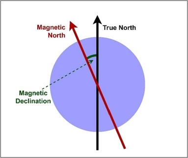
To put this in a nutshell, your charts are all measured in true magnetic based on latitude and longitude. So the heading you see on your chart may differ substantially from the heading that you see on your compass. So this difference needs to be first identified and then calculated. This is because the skipper’s calculation, based on his chart, is, for example, 215 degrees, whereas the helmsman needs to steer a heading of 219 degrees.
Factors Affecting Compass Variation
Variation changes depending on location because the Earth’s magnetic field is irregular. Some key influences include:
- Earth’s Magnetic Field: The core and crust of the Earth create shifting magnetic forces.
- Location: Different regions have different variation values, which can be found on nautical or aeronautical charts.
- Time: Variation gradually changes over the years due to shifts in the Earth’s magnetic field, requiring updated charts.
Correcting for Compass Variation
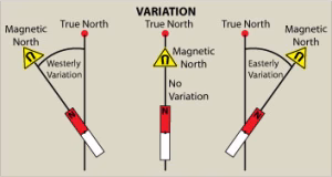
Since variation is specific to a location, navigators correct it by referencing a compass rose on nautical charts. This rose shows both true north and magnetic north, allowing navigators to apply the variation correction to their compass heading.
Let’s take a look at how to find and calculate compass variation in your local area. Consider the compass rose below. You can find these in multiple locations on your local chart. Each compass rose will provide you with the necessary information to calculate an up-to-date compass variation.
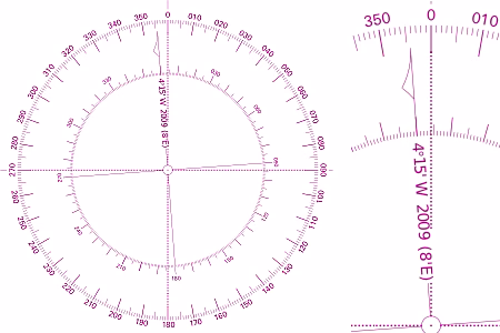
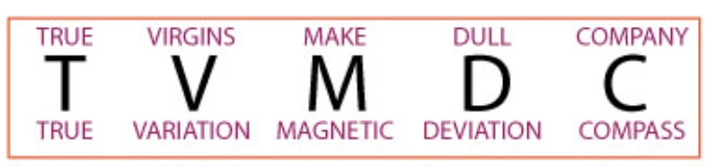
As you can see, the compass variation on this compass rose was determined in 2009 by individuals on a much higher pay grade than ours. The variation in 2009 was 4 degrees and 15 minutes West. The information also reveals that for each year that passes, the variation changes 8 minutes East. We then determine the difference in years between then and now (or whenever you are reading this): 2025 – 2009 = 16 years. It then follows that 16 x 8 minutes = 128 minutes. So that is an additional 2° and 8′ East since 2009. Remembering the acronym T-V-M-D-C (Add West) (see the memory aid at the end of this article), we know to subtract if it is East. 4°15′ – 2°8′ = 2°7′. So there you are, your compass variation (the difference between true and magnetic) is 2°7′.
Compass Deviation
Definition and Cause
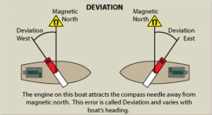
Compass deviation is the error caused by local magnetic interference on board a vessel. Unlike variation, which affects all compasses in a given region equally, deviation is unique to each compass and depends on the metal objects and electrical systems near it.
Factors Affecting Compass Deviation
- Ship’s Metal Structure: Iron, steel, and other magnetic materials distort the compass reading.
- Electrical Systems: Current running through electrical circuits can induce magnetic fields that interfere with the compass.
- Cargo and Equipment: Some loads (such as large metal containers) can temporarily alter deviation.
- Heading of the Vessel: Deviation often changes with direction because the compass interacts with onboard magnetic influences differently at different headings.
Correcting for Compass Deviation
Deviation is measured by performing a compass swing, where a vessel is turned in a full circle while comparing the ship’s compass to a known accurate heading. A deviation card is then created, listing corrections for various headings. A compass deviation card may look something like the following:
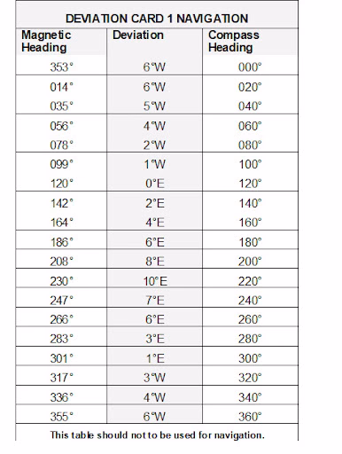
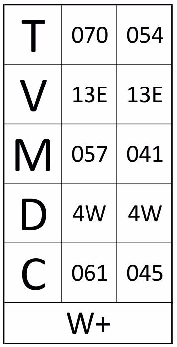
You are required to do some interpolation, as not every degree is shown in the table. Plug these figures into your T-V-M-D-C AT WEDDINGS (see memory aid below) and voila…
Summary of Differences
Factor | Compass Variation | Compass Deviation |
|---|---|---|
Cause | Earth’s magnetic field | Local magnetic influences on the vessel |
Changes with Location? | Yes | No |
Changes with Heading? | No | Yes |
Correction Method | Use a chart’s variation value | Use a deviation card for specific compass corrections |
Memory Aid
Please do not shoot me for this, but when I grew up and learned this stuff, the political correctness was somewhat lagging behind today’s standards. However, this is what was ingrained in my brain from day dot… (we also added “at weddings” to the end to remind ourselves to add the variation if it was westerly).
This memory aid could translate into this practical example based on the two calculation methods explained previously:
Understanding and correcting for both variation and deviation ensures accurate navigation. Mariners and aviators must constantly monitor these effects, updating charts and adjusting for onboard influences to maintain reliable course plotting.
Why do we use it? Read more about articles that have this as the foundation for navigation: